Input: Add Lane Closure
Roadway Details
This section explains selection of routes, names, and locations based on RNS data.

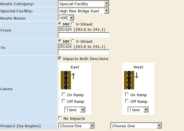
- "Route Category" - Sselectable from the standard type of roadways in the region, such as "Interstate"
- "Special Facility" - Appears and will be visible and selectable if the Route Category is set to "Special Facility". This will display all special facilities in the selected jurisdiction. Selecting one will fill in the route name of the facility and the from/to mile markers in the fields below.
- "Route Name" - Displays a drop-down list of route numbers based on a combination of "Jurisdiction" and "Route Category"
- The available routes are based on available RNS data. If no selections are available, change the "Route Category" to a different selection.
- "From/To" - Each lane closure must have a starting and an end point. The point may be defined by either a mile marker value or cross-street.

- Mile markers (MM) may be manually entered as a decimal value, or selected graphically using the appropriate “mark to/from” radio buttons located at the bottom of the map panel. The user can click on the selected roadway in the map window, and a mile marker value corresponding to the point will then be filled into the "From/To" fields.
- Alternatively, a cross-street location (intersection) may be chosen by changing the radio button on the web form from “MM” to "X-Street" and then making a selection from the drop-down box that appears. [Note: Descriptions are provided by the VDOT RNS dataset. Every cross-street location also has a corresponding MM value.]
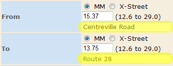
- Optionally, the user can choose to manually override intersection descriptions with something more meaningful for display on reports. This is done by entering a description in the text box below the location and is highlighted in the image on the right. In this manner, instead of "Rt. 846S from 15.37 to 13.75", the report will show "Rt. 846S from Centreville Road to Route 28". The underlying point is not changed by changing the description.
- "Lanes" - Provides a graphical representation of the roadway and should automatically provide the actual number of lanes when the "Route Name" field has been provided.
a. Click on the lane(s) and shoulder(s) to represent lane closure. They will be highlighted in "red". Note that LCAMS is dependent on RNS data which may not be complete. If the number of lanes available are not automatically displayed, this selection will need to be performed manually.
- "Impacts Both Directions" - For routes with opposite direction routes defined in the data, the "Impacts Both Directions" checkbox will be enabled (Note that this screen shot shows it clicked with a Special Facility - this is only for demonstration). When this is clicked, a second lane widget will be opened allowing users to indicate lane closures going in the opposite direction. If a lane is marked in this opposite direction, then an opposite direction closure will be created and will be used in conflict detection as any other closure would be.
- "No Impacts" - This checkbox indicates no lane, shoulder, or ramp closures will be associated with this Closure.
Data Retrieval Notification
 To account for differences in network speed, an animated "downloading" icon has been added to a number of fields. It is a visual prompt that appears to the right of the pull-down menu and users are instructed not to make other selections until the icon disappears.


 To account for differences in network speed, an animated "downloading" icon has been added to a number of fields. It is a visual prompt that appears to the right of the pull-down menu and users are instructed not to make other selections until the icon disappears.