Map View: Map Layers
The Control Panel

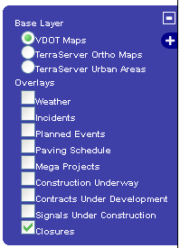
The Map Layers Control Panel is accessed by selecting the "+" icon next to the calendars and allows a view of LCAMS, VaTraffic, RNS, and other data on the map. When open, a number of layers can be toggled on and off.
- VDOT Maps - The default layer that provides graphical representation of the Roadway Network System (RNS) data.
- TerraServer Ortho Maps - TerraServer serves digital imagery of aerial photographs as provided by the U.S. Geological Survey (USGS)
- TerraServer Urban Areas - Similar to the ortho maps provided by TerraServer, urban areas provides higher-resolution photography
- Weather - Activate this control to display live weather patterns across the map
- Incidents - Use this option to quickly identify incidents such as vehicular accidents and disasters (natural/man-made)
- Planned Events - Toggle this field to enable/disable icons displaying workzone events from VaTraffic
- Planning/Process Overlays - Project Managers use these layers to identify potential conflicts across projects. Overlays include: Paving Schedule, Mega Projects, Construction Underway, Contracts Under Development, and Signals Under Construction
- Closures - This layer controls the display of lane closure entered by LCAMS
The "VDOT Maps" and "Closures" layers are enabled by default.
TerraServer
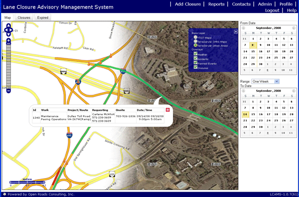
Enabling one of the TerraServer layers will display aerial photographs to provide visual points of reference. The image below provides a side by side view of the standard mapview (left) vs. the digital imagery (right).


![]()